


Comps par l'aiguille

rando30129
User
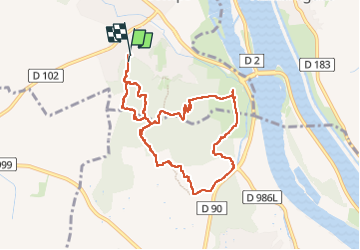

Length
9.5 km

Max alt
140 m

Uphill gradient
294 m
Km-Effort
13.4 km

Min alt
20 m

Downhill gradient
297 m
Boucle
Yes
Creation date :
2023-03-23 12:28:07.53
Updated on :
2023-03-23 16:03:19.218
3h34
Difficulty : Difficult

FREE GPS app for hiking
 SityTrail
IGN / Geographical institutes
SityTrail Plus
The world is yours!
About
Trail Walking of 9.5 km to be discovered at Occitania, Gard, Comps. This trail is proposed by rando30129.
Positioning
Country:
France
Region :
Occitania
Department/Province :
Gard
Municipality :
Comps
Location:
Unknown
Start:(Dec)
Start:(UTM)
628569 ; 4855802 (31T) N.
Comments