


montigné

Yolande Olivier
User
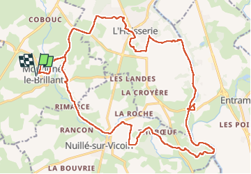

Length
27 km

Max alt
118 m

Uphill gradient
421 m
Km-Effort
33 km

Min alt
36 m

Downhill gradient
421 m
Boucle
Yes
Creation date :
2023-03-21 08:36:56.136
Updated on :
2023-03-24 19:54:59.479
5h41
Difficulty : Very easy

FREE GPS app for hiking
 SityTrail
IGN / Geographical institutes
SityTrail Plus
The world is yours!
About
Trail Walking of 27 km to be discovered at Pays de la Loire, Mayenne, Montigné-le-Brillant. This trail is proposed by Yolande Olivier.
Description
rando
Positioning
Country:
France
Region :
Pays de la Loire
Department/Province :
Mayenne
Municipality :
Montigné-le-Brillant
Location:
Unknown
Start:(Dec)
Start:(UTM)
662825 ; 5319495 (30U) N.
Comments