


G1-Glovettes-Lans les Allières

lionelnottat
User
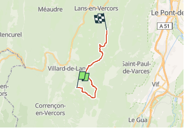

Length
12.7 km

Max alt
1534 m

Uphill gradient
657 m
Km-Effort
21 km

Min alt
1163 m

Downhill gradient
597 m
Boucle
No
Creation date :
2023-03-25 07:40:59.917
Updated on :
2023-03-25 07:42:03.362
0m
Difficulty : Medium

FREE GPS app for hiking
 SityTrail
IGN / Geographical institutes
SityTrail Plus
The world is yours!
About
Trail Snowshoes of 12.7 km to be discovered at Auvergne-Rhône-Alpes, Isère, Villard-de-Lans. This trail is proposed by lionelnottat.
Positioning
Country:
France
Region :
Auvergne-Rhône-Alpes
Department/Province :
Isère
Municipality :
Villard-de-Lans
Location:
Unknown
Start:(Dec)
Start:(UTM)
701802 ; 4991940 (31T) N.
Comments