


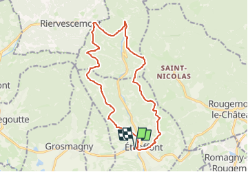
Etueffont Madeleine Val des Anges

Alain28/01
User

Length
16 km

Max alt
805 m

Uphill gradient
519 m
Km-Effort
23 km

Min alt
447 m

Downhill gradient
518 m
Boucle
Yes
Creation date :
2023-03-26 10:01:18.304
Updated on :
2023-03-26 10:03:05.477
5h12
Difficulty : Very difficult

FREE GPS app for hiking
 SityTrail
IGN / Geographical institutes
SityTrail Plus
The world is yours!
About
Trail Walking of 16 km to be discovered at Bourgogne-Franche-Comté, Territoire-de-Belfort, Étueffont. This trail is proposed by Alain28/01.
Positioning
Country:
France
Region :
Bourgogne-Franche-Comté
Department/Province :
Territoire-de-Belfort
Municipality :
Étueffont
Location:
Unknown
Start:(Dec)
Start:(UTM)
343896 ; 5287550 (32T) N.
Comments