


Luynes Rodari

MAUVAGE Patrick
User
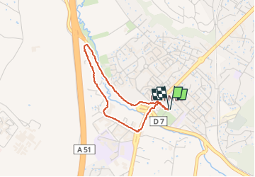

Length
2.9 km

Max alt
156 m

Uphill gradient
23 m
Km-Effort
3.2 km

Min alt
138 m

Downhill gradient
22 m
Boucle
Yes
Creation date :
2023-03-26 14:34:26.0
Updated on :
2023-03-26 18:19:00.079
39m
Difficulty : Unknown

FREE GPS app for hiking
 SityTrail
IGN / Geographical institutes
SityTrail Plus
The world is yours!
About
Trail Walking of 2.9 km to be discovered at Provence-Alpes-Côte d'Azur, Bouches-du-Rhône, Aix-en-Provence. This trail is proposed by MAUVAGE Patrick.
Positioning
Country:
France
Region :
Provence-Alpes-Côte d'Azur
Department/Province :
Bouches-du-Rhône
Municipality :
Aix-en-Provence
Location:
Unknown
Start:(Dec)
Start:(UTM)
695621 ; 4817287 (31T) N.
Comments