Trail Hybrid bike Fleurines - randonnée Au5v OT Ccpoh halatte - Photo

randonnée Au5v OT Ccpoh halatte

© OpenStreetMap contributors
Length
Length
30 km
Max alt
Max alt
202 m
Uphill gradient
Uphill gradient
381 m
Km-Effort
Km-Effort  
35 km
Min alt
Min alt
93 m
Downhill gradient
Downhill gradient
381 m
Boucle
Boucle
Yes
Creation date :
2023-03-27 07:49:10.064
Updated on :
2023-04-26 07:43:59.37

(0 Reviews)

Hybrid bike
Hybrid bike
--
Difficulty : Easy

Scan this QR Code to open this trail in the SityTrail application

FREE GPS app for hiking

Logo SityTrail SityTrail

IGN / Geographical institutes

Download SityTrail from the App Store Download SityTrail from Google Play

Logo SityTrail SityTrail World

The world is yours!

Download SityTrail from the App Store Download SityTrail from Google Play Download SityTrail on Huawei AppGallery

About

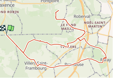
Trail Hybrid bike of 30 km to be discovered at Hauts-de-France, Oise, Fleurines. This trail is proposed by gilbertdu60.

Description

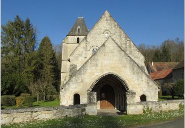
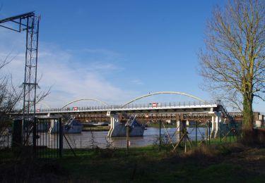
« Entre campagne et forêt domaniale »
départ aux coordonnées GPS 49°16'13.0"N 2°36'59.5"E  
En direction des plateaux, à la lisière des bois et des hautes futaies de la forêt d’Halatte, vers Raray, Yvillers Barbery et Villers St Frambourg.

Elevation profile

Photos

Positioning

Country:
France
Region :
Hauts-de-France
Department/Province :
Oise
Municipality :
Fleurines
Location:
Unknown
Start:(UTM)
471398 ; 5458366 (31U) N.

Trails nearby

Trail Walking Villers-Saint-Frambourg-Ognon - MR_OGNON (par BALAGNY-sur-AUNETTE)_5.4Km - Photo
Walking

Walking

Medium
(3)
Villers-Saint-Frambourg-Ognon, Hauts-de-France, Oise, France
5.4 km | 6.4 km-effort
1h 27min
Yes
Trail Walking Beaurepaire - La mare aux oiseaux - Beaurepaire - Photo
Walking
tracegps

Walking

Medium
(1)
Beaurepaire, Hauts-de-France, Oise, France
8.4 km | 10.2 km-effort
2h 10min
Yes
Trail Walking Fleurines - Fleurines Grand parcours - Photo
Walking
CC.RIDER

Walking

Easy
(1)
Fleurines, Hauts-de-France, Oise, France
20 km | 24 km-effort
5h 8min
Yes
Trail Walking Chamant - Chamant Supermini-rando - Photo
Walking
CC.RIDER

Walking

Easy
(8)
Chamant, Hauts-de-France, Oise, France
8 km | 9.3 km-effort
2h 7min
Yes
Trail Walking Pontpoint - Mont Pagnotte Grand parcours - Photo
Walking
CC.RIDER

Walking

Medium
(2)
Pontpoint, Hauts-de-France, Oise, France
16.6 km | 22 km-effort
4h 36min
Yes
Trail Bicycle tourism Pont-Sainte-Maxence - sortie AU5v Pentecôte 2022 - Photo
Bicycle tourism
gilbertdu60

Bicycle tourism

Easy
Pont-Sainte-Maxence, Hauts-de-France, Oise, France
26 km | 29 km-effort
Unknown
Yes
Trail On foot Pont-Sainte-Maxence - balade pedestre 11 avril 2022 - Photo
On foot
gilbertdu60

On foot

Easy
Pont-Sainte-Maxence, Hauts-de-France, Oise, France
7.2 km | 9.1 km-effort
2h 4min
Yes
Trail Electric bike Pont-Sainte-Maxence - balade printanière du 23 mars - Photo
Electric bike
gilbertdu60

Electric bike

Easy
Pont-Sainte-Maxence, Hauts-de-France, Oise, France
22 km | 26 km-effort
2h 14min
Yes
Trail Electric bike Pont-Sainte-Maxence - sortie 18 janvier 22 - Photo
Electric bike
gilbertdu60

Electric bike

Easy
Pont-Sainte-Maxence, Hauts-de-France, Oise, France
23 km | 27 km-effort
2h 4min
Yes


Close
My subscriptions