Trail Walking Utelle - 
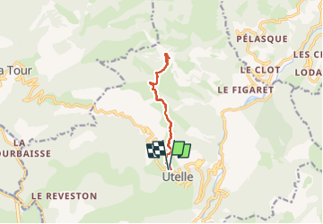
Utelle, Brec d'Utelle - Photo
 GrouGary
GrouGary

User

© OpenStreetMap contributors
Length
Length
11.2 km
Max alt
Max alt
1570 m
Uphill gradient
Uphill gradient
809 m
Km-Effort
Km-Effort  
22 km
Min alt
Min alt
812 m
Downhill gradient
Downhill gradient
809 m
Boucle
Boucle
Yes
Creation date :
2023-03-28 06:56:08.626
Updated on :
2024-04-06 11:58:50.015

(1 Reviews)

Walking
Walking
4h59
Difficulty : Very difficult

Scan this QR Code to open this trail in the SityTrail application

FREE GPS app for hiking

Logo SityTrail SityTrail

IGN / Geographical institutes

Download SityTrail from the App Store Download SityTrail from Google Play

Logo SityTrail SityTrail Plus

The world is yours!

Download SityTrail from the App Store Download SityTrail from Google Play Download SityTrail on Huawei AppGallery

About

Trail Walking of 11.2 km to be discovered at Provence-Alpes-Côte d'Azur, Maritime Alps, Utelle. This trail is proposed by GrouGary.

Description

Un A/R empruntant le GR5, avec de superbes vues en balcons sur le côté "Tinée" ou le côté "Vésubie" ; Et le Mercantour enneigé visible depuis l'Argentera plus au Nord, vers la cime du Diable...
En montant vers le Brec d'Utelle, "Castel Ginestel" a des allures de "Mont Aiguille " dans le Vercors Sud ;
Aucune difficulté technique. Montée soutenue mais régulière. On met quelques mains sur la brèche, en haut du Brec d'Utelle.

Elevation profile

Photos

Positioning

Country:
France
Region :
Provence-Alpes-Côte d'Azur
Department/Province :
Maritime Alps
Municipality :
Utelle
Location:
Unknown
Start:(UTM)
359068 ; 4864353 (32T) N.

Comments

Please log in to post a review or rate the element


Comme toujours, extra


Close
My subscriptions