


z Palayson 28-03-23

cb8310
User
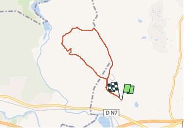

Length
6.3 km

Max alt
93 m

Uphill gradient
91 m
Km-Effort
7.5 km

Min alt
35 m

Downhill gradient
88 m
Boucle
Yes
Creation date :
2023-03-28 12:01:04.313
Updated on :
2023-03-29 06:41:39.944
1h41
Difficulty : Medium

FREE GPS app for hiking
 SityTrail
IGN / Geographical institutes
SityTrail Plus
The world is yours!
About
Trail Walking of 6.3 km to be discovered at Provence-Alpes-Côte d'Azur, Var, Roquebrune-sur-Argens. This trail is proposed by cb8310.
Description
parcours vallonné sans difficultés majeures
Positioning
Country:
France
Region :
Provence-Alpes-Côte d'Azur
Department/Province :
Var
Municipality :
Roquebrune-sur-Argens
Location:
Unknown
Start:(Dec)
Start:(UTM)
307388 ; 4815699 (32T) N.
Comments