


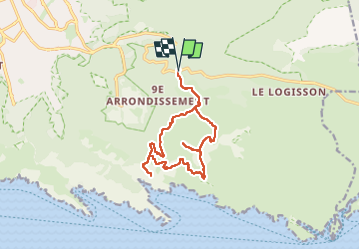
Mont PUGET

michelpaulin
User

Length
14.8 km

Max alt
554 m

Uphill gradient
625 m
Km-Effort
23 km

Min alt
204 m

Downhill gradient
621 m
Boucle
Yes
Creation date :
2023-03-28 07:05:07.0
Updated on :
2023-03-28 14:16:45.959
5h14
Difficulty : Very difficult

FREE GPS app for hiking
 SityTrail
IGN / Geographical institutes
SityTrail Plus
The world is yours!
About
Trail Walking of 14.8 km to be discovered at Provence-Alpes-Côte d'Azur, Bouches-du-Rhône, Marseille. This trail is proposed by michelpaulin.
Description
Très belle rando
Positioning
Country:
France
Region :
Provence-Alpes-Côte d'Azur
Department/Province :
Bouches-du-Rhône
Municipality :
Marseille
Location:
9th Arrondissement
Start:(Dec)
Start:(UTM)
699492 ; 4790404 (31T) N.
Comments