


Roncherolles sur le Vivier ML

Childebert
User
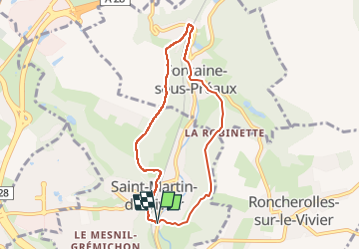

Length
6.6 km

Max alt
153 m

Uphill gradient
213 m
Km-Effort
9.4 km

Min alt
51 m

Downhill gradient
213 m
Boucle
Yes
Creation date :
2023-03-28 19:08:50.451
Updated on :
2023-04-15 18:48:08.82
2h08
Difficulty : Medium

FREE GPS app for hiking
 SityTrail
IGN / Geographical institutes
SityTrail Plus
The world is yours!
About
Trail Walking of 6.6 km to be discovered at Normandy, Seine-Maritime, Saint-Martin-du-Vivier. This trail is proposed by Childebert.
Positioning
Country:
France
Region :
Normandy
Department/Province :
Seine-Maritime
Municipality :
Saint-Martin-du-Vivier
Location:
Unknown
Start:(Dec)
Start:(UTM)
366760 ; 5480881 (31U) N.
Comments