


Tram

jwo47
User
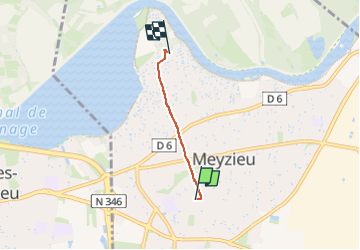

Length
2.4 km

Max alt
200 m

Uphill gradient
2 m
Km-Effort
2.4 km

Min alt
190 m

Downhill gradient
12 m
Boucle
No
Creation date :
2023-03-29 15:10:17.0
Updated on :
2023-03-29 15:42:01.254
31m
Difficulty : Easy

FREE GPS app for hiking
 SityTrail
IGN / Geographical institutes
SityTrail Plus
The world is yours!
About
Trail Walking of 2.4 km to be discovered at Auvergne-Rhône-Alpes, Métropole de Lyon, Meyzieu. This trail is proposed by jwo47.
Positioning
Country:
France
Region :
Auvergne-Rhône-Alpes
Department/Province :
Métropole de Lyon
Municipality :
Meyzieu
Location:
Unknown
Start:(Dec)
Start:(UTM)
655473 ; 5070626 (31T) N.
Comments