


Trail Planner Map

daniel_2w
User
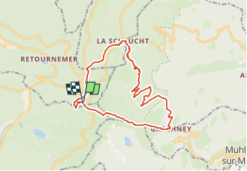

Length
16.1 km

Max alt
1341 m

Uphill gradient
774 m
Km-Effort
26 km

Min alt
824 m

Downhill gradient
767 m
Boucle
Yes
Creation date :
2023-03-30 08:34:49.417
Updated on :
2023-03-30 08:38:15.573
0m
Difficulty : Medium

FREE GPS app for hiking
 SityTrail
IGN / Geographical institutes
SityTrail Plus
The world is yours!
About
Trail Nordic walking of 16.1 km to be discovered at Grand Est, Vosges, Xonrupt-Longemer. This trail is proposed by daniel_2w.
Positioning
Country:
France
Region :
Grand Est
Department/Province :
Vosges
Municipality :
Xonrupt-Longemer
Location:
Unknown
Start:(Dec)
Start:(UTM)
351141 ; 5322989 (32U) N.
Comments