


13 Gignac Gipieres vierge chapelle

Nathy8913
User
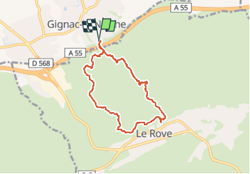

Length
7.3 km

Max alt
224 m

Uphill gradient
238 m
Km-Effort
10.5 km

Min alt
78 m

Downhill gradient
238 m
Boucle
Yes
Creation date :
2023-03-30 11:58:37.293
Updated on :
2023-03-30 17:04:25.838
2h22
Difficulty : Medium

FREE GPS app for hiking
 SityTrail
IGN / Geographical institutes
SityTrail Plus
The world is yours!
About
Trail Walking of 7.3 km to be discovered at Provence-Alpes-Côte d'Azur, Bouches-du-Rhône, Gignac-la-Nerthe. This trail is proposed by Nathy8913.
Positioning
Country:
France
Region :
Provence-Alpes-Côte d'Azur
Department/Province :
Bouches-du-Rhône
Municipality :
Gignac-la-Nerthe
Location:
Unknown
Start:(Dec)
Start:(UTM)
681123 ; 4806067 (31T) N.
Comments