


Heuvelland (RD1)+/-40Km

Ronalddef
User
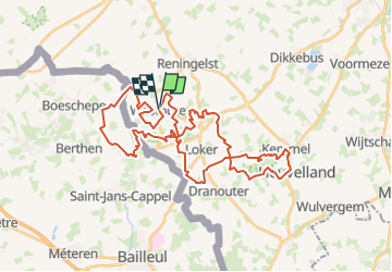

Length
39 km

Max alt
156 m

Uphill gradient
708 m
Km-Effort
48 km

Min alt
34 m

Downhill gradient
707 m
Boucle
Yes
Creation date :
2023-03-31 12:53:50.213
Updated on :
2023-03-31 12:58:38.5
--
Difficulty : Difficult

FREE GPS app for hiking
 SityTrail
IGN / Geographical institutes
SityTrail Plus
The world is yours!
About
Trail Trail of 39 km to be discovered at Flanders, West Flanders, Heuvelland. This trail is proposed by Ronalddef.
Description
Gemaakt met SityTrail /-40Km D 780m
Positioning
Country:
Belgium
Region :
Flanders
Department/Province :
West Flanders
Municipality :
Heuvelland
Location:
Westouter
Start:(Dec)
Start:(UTM)
482082 ; 5627471 (31U) N.
Comments