


Hauts de Gaillac.

chripaci
User
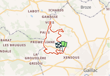

Length
13.2 km

Max alt
288 m

Uphill gradient
269 m
Km-Effort
16.8 km

Min alt
172 m

Downhill gradient
285 m
Boucle
No
Creation date :
2023-04-02 06:54:50.0
Updated on :
2023-04-03 21:21:03.792
2h47
Difficulty : Difficult

FREE GPS app for hiking
 SityTrail
IGN / Geographical institutes
SityTrail Plus
The world is yours!
About
Trail Nordic walking of 13.2 km to be discovered at Occitania, Tarn, Gaillac. This trail is proposed by chripaci.
Description
Belle marche avec en fin de parcours des escaliers bien « cardio »
Positioning
Country:
France
Region :
Occitania
Department/Province :
Tarn
Municipality :
Gaillac
Location:
Unknown
Start:(Dec)
Start:(UTM)
408639 ; 4863338 (31T) N.
Comments