


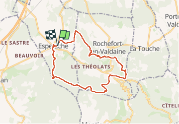
Espeluche chateau de rochefort

Danielle07
User

Length
17.2 km

Max alt
410 m

Uphill gradient
455 m
Km-Effort
23 km

Min alt
160 m

Downhill gradient
454 m
Boucle
Yes
Creation date :
2023-04-02 07:30:39.101
Updated on :
2025-01-18 15:11:15.928
5h17
Difficulty : Medium

FREE GPS app for hiking
 SityTrail
IGN / Geographical institutes
SityTrail Plus
The world is yours!
About
Trail Walking of 17.2 km to be discovered at Auvergne-Rhône-Alpes, Drôme, Espeluche. This trail is proposed by Danielle07.
Description
tracé en évitant le plus possible de piste, passage au très beau château de Rochefort en Valdaine, visite de village médiéval d'Espeluche
Parling au stade
Positioning
Country:
France
Region :
Auvergne-Rhône-Alpes
Department/Province :
Drôme
Municipality :
Espeluche
Location:
Unknown
Start:(Dec)
Start:(UTM)
645154 ; 4930847 (31T) N.
Comments