


LES TANNARDS - Grand bois de d’alouette

nicolasdresse
User
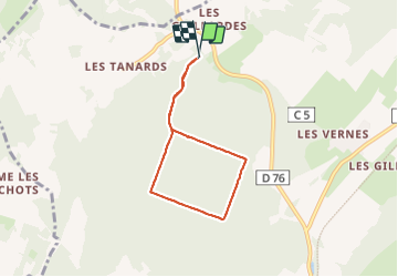

Length
5.4 km

Max alt
367 m

Uphill gradient
118 m
Km-Effort
7 km

Min alt
295 m

Downhill gradient
119 m
Boucle
Yes
Creation date :
2023-04-02 15:36:34.0
Updated on :
2023-06-18 13:55:15.447
1h58
Difficulty : Medium

FREE GPS app for hiking
 SityTrail
IGN / Geographical institutes
SityTrail Plus
The world is yours!
About
Trail Walking of 5.4 km to be discovered at Bourgogne-Franche-Comté, Haute-Saône, Dampierre-sur-Linotte. This trail is proposed by nicolasdresse.
Positioning
Country:
France
Region :
Bourgogne-Franche-Comté
Department/Province :
Haute-Saône
Municipality :
Dampierre-sur-Linotte
Location:
Unknown
Start:(Dec)
Start:(UTM)
291766 ; 5270122 (32T) N.
Comments