


Rd-Murs-Veroncle

raymondfn
User
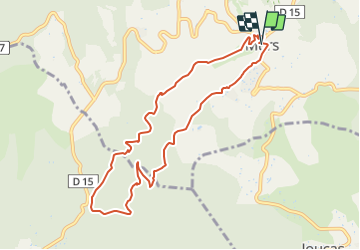

Length
9.5 km

Max alt
522 m

Uphill gradient
266 m
Km-Effort
13.1 km

Min alt
376 m

Downhill gradient
268 m
Boucle
Yes
Creation date :
2023-04-03 13:30:08.186
Updated on :
2023-06-06 18:28:26.972
2h58
Difficulty : Difficult

FREE GPS app for hiking
 SityTrail
IGN / Geographical institutes
SityTrail Plus
The world is yours!
About
Trail Walking of 9.5 km to be discovered at Provence-Alpes-Côte d'Azur, Vaucluse, Murs. This trail is proposed by raymondfn.
Positioning
Country:
France
Region :
Provence-Alpes-Côte d'Azur
Department/Province :
Vaucluse
Municipality :
Murs
Location:
Unknown
Start:(Dec)
Start:(UTM)
679919 ; 4868910 (31T) N.
Comments