


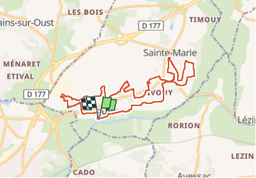
03/04/2023 - Sté Marie de Redon sud

babeth35
User

Length
20 km

Max alt
49 m

Uphill gradient
240 m
Km-Effort
24 km

Min alt
2 m

Downhill gradient
240 m
Boucle
Yes
Creation date :
2023-04-03 06:50:41.0
Updated on :
2023-04-03 14:45:17.063
4h54
Difficulty : Easy

FREE GPS app for hiking
 SityTrail
IGN / Geographical institutes
SityTrail Plus
The world is yours!
About
Trail Walking of 20 km to be discovered at Brittany, Ille-et-Vilaine, Sainte-Marie. This trail is proposed by babeth35.
Positioning
Country:
France
Region :
Brittany
Department/Province :
Ille-et-Vilaine
Municipality :
Sainte-Marie
Location:
Unknown
Start:(Dec)
Start:(UTM)
572465 ; 5280355 (30T) N.
Comments