


echaillon roc taulau

THIOLIER
User
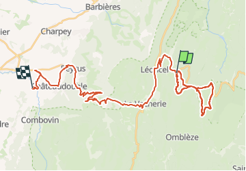

Length
46 km

Max alt
1566 m

Uphill gradient
931 m
Km-Effort
61 km

Min alt
290 m

Downhill gradient
1844 m
Boucle
No
Creation date :
2021-04-08 08:24:48.22
Updated on :
2023-04-04 04:36:07.714
6h58
Difficulty : Very difficult

FREE GPS app for hiking
 SityTrail
IGN / Geographical institutes
SityTrail Plus
The world is yours!
About
Trail Walking of 46 km to be discovered at Auvergne-Rhône-Alpes, Drôme, Léoncel. This trail is proposed by THIOLIER.
Description
bla
Positioning
Country:
France
Region :
Auvergne-Rhône-Alpes
Department/Province :
Drôme
Municipality :
Léoncel
Location:
Unknown
Start:(Dec)
Start:(UTM)
674788 ; 4975202 (31T) N.
Comments