Trail Walking Sahurs - Sahurs 11KM - Photo
© OpenStreetMap contributors
Length
Length
10.9 km
Max alt
Max alt
57 m
Uphill gradient
Uphill gradient
93 m
Km-Effort
Km-Effort  
12.2 km
Min alt
Min alt
-1 m
Downhill gradient
Downhill gradient
94 m
Boucle
Boucle
Yes
Creation date :
2014-12-10 00:00:00.0
Updated on :
2014-12-10 00:00:00.0

(0 Reviews)

Walking
Walking
2h41
Difficulty : Easy

Scan this QR Code to open this trail in the SityTrail application

FREE GPS app for hiking

Logo SityTrail SityTrail

IGN / Geographical institutes

Download SityTrail from the App Store Download SityTrail from Google Play

Logo SityTrail SityTrail World

The world is yours!

Download SityTrail from the App Store Download SityTrail from Google Play Download SityTrail on Huawei AppGallery

About

Trail Walking of 10.9 km to be discovered at Normandy, Seine-Maritime, Sahurs. This trail is proposed by philippe76.

Description

Point de départ, parking du "Clos des Roses". prendre la rue de Marbeuf puis la première à droite pour rejoindre le chemin de halage.
(prendre le chemin étroit passer par le petit tourniquet).
AG dans le chemin de halage puis 1ère AG et AD rue de Seine jusqu'à la D51. AD et Traverser la D51 pour prendre le chemin du Canada en face.
Passer devant le lieu dit "Le Canada" et Aller TD.
Prendre à gauche le chemin, traverser la D351,TD au prochain chemin et AG pour redescendre vers la vallée.
Traverser "La grande voie" la D51 en prenant la rue Maze.
AD rue du Puits Fouquet, et AG à la Chaussée de Caumont pour rejoindre le chemin de Halage. AG en suivant la Seine jusqu'au bac. Prendre AG La Chaussée de la Bouille (D67) pour rejoindre le parking du "Clos des Roses".

Elevation profile

Positioning

Country:
France
Region :
Normandy
Department/Province :
Seine-Maritime
Municipality :
Sahurs
Location:
Unknown
Start:(UTM)
350704 ; 5469238 (31U) N.

Trails nearby

Trail Walking Hautot-sur-Seine - Hautot-sur-seine  11km  - Photo
Walking
MichelRando7656

Walking

Medium
(2)
Hautot-sur-Seine, Normandy, Seine-Maritime, France
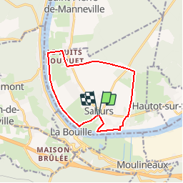
11 km | 12.2 km-effort
2h 37min
Yes
Trail Walking Saint-Ouen-de-Thouberville - Saint-Ouen de Thouberville- Le Mesnil et la Pierre TTournante  - Photo
Walking
MichelRando7656

Walking

Medium
(1)
Saint-Ouen-de-Thouberville, Normandy, Eure, France
12.5 km | 15.3 km-effort
3h 35min
Yes
Trail Walking Moulineaux - Robert-le-Diable - château - GD - V2 - Photo
Walking
philippe76

Walking

Difficult
(1)
Moulineaux, Normandy, Seine-Maritime, France
10.4 km | 13.1 km-effort
2h 58min
Yes
Trail On foot Saint-Pierre-de-Manneville - Du coté du Manoir de Villers - Photo
On foot
JMCMoreau

On foot

Easy
(1)
Saint-Pierre-de-Manneville, Normandy, Seine-Maritime, France
11 km | 12.5 km-effort
2h 45min
Yes
Trail Walking La Londe - 20240507-La Londe Cool - Photo
Walking
doudet

Walking

Easy
La Londe, Normandy, Seine-Maritime, France
7.3 km | 9.2 km-effort
2h 15min
Yes
Trail Walking Saint-Pierre-de-Manneville - st pierre de mainneville - Photo
Walking
Philippe Auguste

Walking

Medium
Saint-Pierre-de-Manneville, Normandy, Seine-Maritime, France
7.6 km | 8.9 km-effort
1h 25min
Yes
Trail Walking La Bouille - La Bouille- Cote Albert Lambert-Robert le Diable - Photo
Walking
MichelRando7656

Walking

Difficult
La Bouille, Normandy, Seine-Maritime, France
14.9 km | 18.8 km-effort
4h 23min
Yes
Trail Walking Moulineaux - 20240227-Moulineaux  Cool - Photo
Walking
doudet

Walking

Easy
Moulineaux, Normandy, Seine-Maritime, France
7.8 km | 8.7 km-effort
1h 49min
Yes
Trail Walking Sahurs - 20231216-sahurs - Photo
Walking
doudet

Walking

Medium
Sahurs, Normandy, Seine-Maritime, France
12.8 km | 14.2 km-effort
3h 18min
Yes


Close
My subscriptions