


MARDI 2023.04.04 - Aqueduc de Nîmes, de St-Bonnet au Gardon

rando30129
User
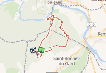

Length
8.8 km

Max alt
148 m

Uphill gradient
245 m
Km-Effort
12 km

Min alt
26 m

Downhill gradient
246 m
Boucle
Yes
Creation date :
2023-04-04 11:28:59.0
Updated on :
2023-04-21 09:05:53.679
2h44
Difficulty : Difficult

FREE GPS app for hiking
 SityTrail
IGN / Geographical institutes
SityTrail Plus
The world is yours!
About
Trail Walking of 8.8 km to be discovered at Occitania, Gard, Saint-Bonnet-du-Gard. This trail is proposed by rando30129.
Description
Parfait !

Positioning
Country:
France
Region :
Occitania
Department/Province :
Gard
Municipality :
Saint-Bonnet-du-Gard
Location:
Unknown
Start:(Dec)
Start:(UTM)
622721 ; 4865283 (31T) N.
Comments