Trail Walking Fontainebleau - retour Brigands - Office Tourisme - Photo

retour Brigands - Office Tourisme

 jcm17
jcm17

User

© OpenStreetMap contributors
Length
Length
3.4 km
Max alt
Max alt
101 m
Uphill gradient
Uphill gradient
19 m
Km-Effort
Km-Effort  
3.6 km
Min alt
Min alt
80 m
Downhill gradient
Downhill gradient
27 m
Boucle
Boucle
No
Creation date :
2023-04-04 16:26:42.624
Updated on :
2023-04-04 16:47:19.878

(0 Reviews)

Walking
Walking
49m
Difficulty : Easy

Scan this QR Code to open this trail in the SityTrail application

FREE GPS app for hiking

Logo SityTrail SityTrail

IGN / Geographical institutes

Download SityTrail from the App Store Download SityTrail from Google Play

Logo SityTrail SityTrail Plus

The world is yours!

Download SityTrail from the App Store Download SityTrail from Google Play Download SityTrail on Huawei AppGallery

About

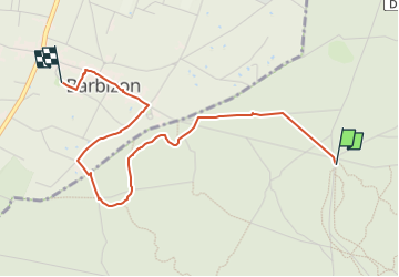
Trail Walking of 3.4 km to be discovered at Ile-de-France, Seine-et-Marne, Fontainebleau. This trail is proposed by jcm17.

Description

Itinéraire très facile (3,5 km en 1h30 sans dénivelé) ;  retour du restaurant de la Caverne des Brigands au parking de l'Office du Tourisme en passant par les points remarquables :
chêne Charlemagne, monument Millet, rocher de l'Elephant, rue de la Belle Marie et ses villas donnant sur le Bornage, rue Grande, maison de J-F Millet, maison de Théodore Rousseau)

Elevation profile

Positioning

Country:
France
Region :
Ile-de-France
Department/Province :
Seine-et-Marne
Municipality :
Fontainebleau
Location:
Unknown
Start:(UTM)
472226 ; 5365346 (31U) N.


Close
My subscriptions