


2023-01-31 Premanon

Lucquiaud
User
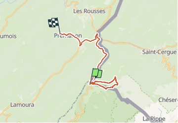

Length
22 km

Max alt
1610 m

Uphill gradient
574 m
Km-Effort
30 km

Min alt
1115 m

Downhill gradient
710 m
Boucle
No
Creation date :
2023-01-31 08:40:06.718
Updated on :
2023-04-05 14:04:19.797
6h37
Difficulty : Very difficult
5h30
Difficulty : Medium

FREE GPS app for hiking
 SityTrail
IGN / Geographical institutes
SityTrail Plus
The world is yours!
About
Trail Walking of 22 km to be discovered at Auvergne-Rhône-Alpes, Ain, Divonne-les-Bains. This trail is proposed by Lucquiaud.
Positioning
Country:
France
Region :
Auvergne-Rhône-Alpes
Department/Province :
Ain
Municipality :
Divonne-les-Bains
Location:
Unknown
Start:(Dec)
Start:(UTM)
274203 ; 5144334 (32T) N.
Comments