


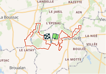
05/04/2023 - De Brégain à Trans la Forêt.Virtuel

babeth35
User

Length
21 km

Max alt
106 m

Uphill gradient
282 m
Km-Effort
25 km

Min alt
36 m

Downhill gradient
281 m
Boucle
Yes
Creation date :
2023-04-05 15:54:42.546
Updated on :
2023-04-05 16:08:29.49
5h37
Difficulty : Medium
5h37
Difficulty : Very difficult

FREE GPS app for hiking
 SityTrail
IGN / Geographical institutes
SityTrail Plus
The world is yours!
About
Trail On foot of 21 km to be discovered at Brittany, Ille-et-Vilaine, Trans-la-Forêt. This trail is proposed by babeth35.
Positioning
Country:
France
Region :
Brittany
Department/Province :
Ille-et-Vilaine
Municipality :
Trans-la-Forêt
Location:
Unknown
Start:(Dec)
Start:(UTM)
602659 ; 5372037 (30U) N.
Comments