


Les Bannières

ARVIEU
User

Length
32 km

Max alt
126 m

Uphill gradient
405 m
Km-Effort
38 km

Min alt
48 m

Downhill gradient
403 m
Boucle
Yes
Creation date :
2023-04-05 16:08:55.776
Updated on :
2023-04-05 16:09:49.455
3h00
Difficulty : Medium

FREE GPS app for hiking
 SityTrail
IGN / Geographical institutes
SityTrail Plus
The world is yours!
About
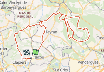
Trail Mountain bike of 32 km to be discovered at Occitania, Hérault, Clapiers. This trail is proposed by ARVIEU.
Positioning
Country:
France
Region :
Occitania
Department/Province :
Hérault
Municipality :
Clapiers
Location:
Unknown
Start:(Dec)
Start:(UTM)
572680 ; 4834501 (31T) N.
Comments