


orgeres le pouez

Pascal Gueno
User
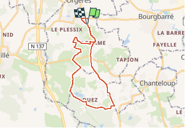

Length
15.4 km

Max alt
107 m

Uphill gradient
168 m
Km-Effort
17.6 km

Min alt
48 m

Downhill gradient
168 m
Boucle
Yes
Creation date :
2023-04-07 11:44:30.973
Updated on :
2023-04-07 14:59:35.819
2h58
Difficulty : Easy

FREE GPS app for hiking
 SityTrail
IGN / Geographical institutes
SityTrail Plus
The world is yours!
About
Trail Walking of 15.4 km to be discovered at Brittany, Ille-et-Vilaine, Orgères. This trail is proposed by Pascal Gueno.
Positioning
Country:
France
Region :
Brittany
Department/Province :
Ille-et-Vilaine
Municipality :
Orgères
Location:
Unknown
Start:(Dec)
Start:(UTM)
599809 ; 5316285 (30T) N.
Comments