Trail Walking Landrecies - Landrecies - 15km - Photo

Landrecies - 15km

 PasGoe
PasGoe

User

© OpenStreetMap contributors
Length
Length
15.7 km
Max alt
Max alt
182 m
Uphill gradient
Uphill gradient
125 m
Km-Effort
Km-Effort  
17.4 km
Min alt
Min alt
130 m
Downhill gradient
Downhill gradient
126 m
Boucle
Boucle
Yes
Creation date :
2023-04-09 06:38:02.629
Updated on :
2023-04-10 09:56:26.589

(1 Reviews)

Walking
Walking
2h40
Difficulty : Medium

Scan this QR Code to open this trail in the SityTrail application

FREE GPS app for hiking

Logo SityTrail SityTrail

IGN / Geographical institutes

Download SityTrail from the App Store Download SityTrail from Google Play

Logo SityTrail SityTrail World

The world is yours!

Download SityTrail from the App Store Download SityTrail from Google Play Download SityTrail on Huawei AppGallery

About

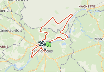
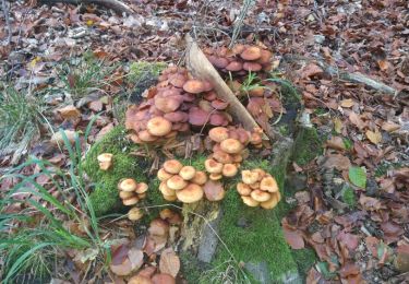
Trail Walking of 15.7 km to be discovered at Hauts-de-France, Nord, Landrecies. This trail is proposed by PasGoe.

Elevation profile

Positioning

Country:
France
Region :
Hauts-de-France
Department/Province :
Nord
Municipality :
Landrecies
Location:
Unknown
Start:(UTM)
549499 ; 5552758 (31U) N.

Comments

Please log in to post a review or rate the element


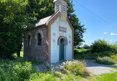
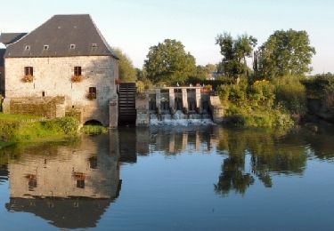
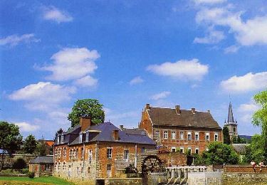
Très beau parcours, varié. Une centaine de mètres embroussaillée avant le canal près de l’arrivée mais ca passe. Parcouru à 4 randonneurs ce 30/9/2023. Merci au concepteur.


Trails nearby

Trail Walking Landrecies - Landrecies 18 km - Photo
Walking
GUIDE
rvapeldo

Walking

Easy
Landrecies, Hauts-de-France, Nord, France
18 km | 20 km-effort
5h 32min
Yes
Trail Mountain bike Maroilles - Circuit Maroilles-Valjoly - Photo
Mountain bike
steph80170

Mountain bike

Difficult
(1)
Maroilles, Hauts-de-France, Nord, France
60 km | 68 km-effort
3h 13min
No
Trail Walking Locquignol - Hachette.  Berges de Sambre et forêt  - Photo
Walking
ayumi atsu

Walking

Medium
Locquignol, Hauts-de-France, Nord, France
9.7 km | 10.9 km-effort
1h 42min
Yes
Trail Walking Maroilles - Maroilles 14 km - Photo
Walking
GUIDE
rvapeldo

Walking

Easy
Maroilles, Hauts-de-France, Nord, France
13.8 km | 15.1 km-effort
3h 47min
Yes
Trail Walking Preux-au-Bois - Circuit de Preux au Bois - Photo
Walking
terminio

Walking

Easy
(1)
Preux-au-Bois, Hauts-de-France, Nord, France
11.3 km | 12.8 km-effort
2h 49min
Yes
Trail Walking Ors - Sentier de bois l'Evèque - Photo
Walking

Walking

Very easy
Ors, Hauts-de-France, Nord, France
6.5 km | 7.3 km-effort
Unknown
Yes
Trail Cycle Maroilles - Moulins et kiosques en Thierache - Maroilles - Photo
Cycle
tracegps

Cycle

Medium
Maroilles, Hauts-de-France, Nord, France
42 km | 46 km-effort
3h 0min
Yes
Trail Walking Landrecies - Sentier des Etoquies - Landrecies - Photo
Walking
tracegps

Walking

Medium
(1)
Landrecies, Hauts-de-France, Nord, France
9.6 km | 10.6 km-effort
2h 25min
Yes
Trail Walking Maroilles - Circuit des Renoncules - Maroilles - Photo
Walking
tracegps

Walking

Medium
(1)
Maroilles, Hauts-de-France, Nord, France
8.6 km | 9.4 km-effort
2h 10min
Yes


Close
My subscriptions