


Bas Oha trail points orange

JM Heine
User
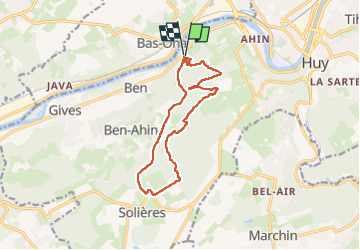

Length
12 km

Max alt
242 m

Uphill gradient
308 m
Km-Effort
16.1 km

Min alt
78 m

Downhill gradient
312 m
Boucle
Yes
Creation date :
2023-04-09 08:26:23.0
Updated on :
2023-04-09 11:24:34.729
2h57
Difficulty : Easy

FREE GPS app for hiking
 SityTrail
IGN / Geographical institutes
SityTrail Plus
The world is yours!
About
Trail Walking of 12 km to be discovered at Wallonia, Liège, Huy. This trail is proposed by JM Heine.
Positioning
Country:
Belgium
Region :
Wallonia
Department/Province :
Liège
Municipality :
Huy
Location:
Unknown
Start:(Dec)
Start:(UTM)
655675 ; 5598684 (31U) N.
Comments