


Eaunes sentiers version 2023 fait

pidjam
User
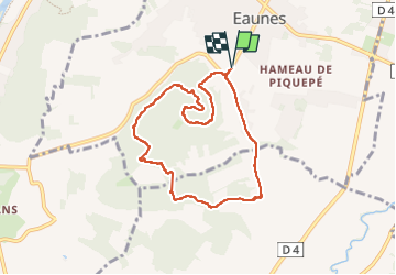

Length
8 km

Max alt
294 m

Uphill gradient
187 m
Km-Effort
10.5 km

Min alt
207 m

Downhill gradient
186 m
Boucle
Yes
Creation date :
2023-04-09 11:53:54.044
Updated on :
2023-04-09 14:02:32.248
1h52
Difficulty : Medium

FREE GPS app for hiking
 SityTrail
IGN / Geographical institutes
SityTrail Plus
The world is yours!
About
Trail Walking of 8 km to be discovered at Occitania, Haute-Garonne, Eaunes. This trail is proposed by pidjam.
Positioning
Country:
France
Region :
Occitania
Department/Province :
Haute-Garonne
Municipality :
Eaunes
Location:
Unknown
Start:(Dec)
Start:(UTM)
366653 ; 4808678 (31T) N.
Comments