


Luynes chemin de la Capelasse

MAUVAGE Patrick
User
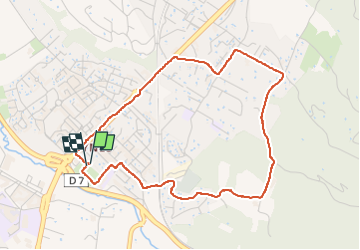

Length
4.8 km

Max alt
237 m

Uphill gradient
100 m
Km-Effort
6.1 km

Min alt
148 m

Downhill gradient
100 m
Boucle
Yes
Creation date :
2023-04-09 15:30:36.0
Updated on :
2023-04-09 16:43:16.497
1h08
Difficulty : Unknown

FREE GPS app for hiking
 SityTrail
IGN / Geographical institutes
SityTrail Plus
The world is yours!
About
Trail Walking of 4.8 km to be discovered at Provence-Alpes-Côte d'Azur, Bouches-du-Rhône, Aix-en-Provence. This trail is proposed by MAUVAGE Patrick.
Positioning
Country:
France
Region :
Provence-Alpes-Côte d'Azur
Department/Province :
Bouches-du-Rhône
Municipality :
Aix-en-Provence
Location:
Unknown
Start:(Dec)
Start:(UTM)
695606 ; 4817285 (31T) N.
Comments