


Jarnioux - Theizé - Frontenas

daniellebou
User
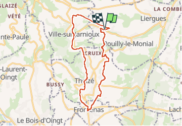

Length
16.1 km

Max alt
486 m

Uphill gradient
451 m
Km-Effort
22 km

Min alt
291 m

Downhill gradient
448 m
Boucle
Yes
Creation date :
2023-04-09 09:57:38.069
Updated on :
2023-04-09 22:16:44.597
5h01
Difficulty : Very difficult

FREE GPS app for hiking
 SityTrail
IGN / Geographical institutes
SityTrail Plus
The world is yours!
About
Trail Walking of 16.1 km to be discovered at Auvergne-Rhône-Alpes, Rhône, Porte des Pierres Dorées. This trail is proposed by daniellebou.
Description
Eviter de faire par temps chaud, très peu d'ombre.
Positioning
Country:
France
Region :
Auvergne-Rhône-Alpes
Department/Province :
Rhône
Municipality :
Porte des Pierres Dorées
Location:
Jarnioux
Start:(Dec)
Start:(UTM)
626286 ; 5091352 (31T) N.
Comments