


Lac de Bonlieu

micheldutilleul
User
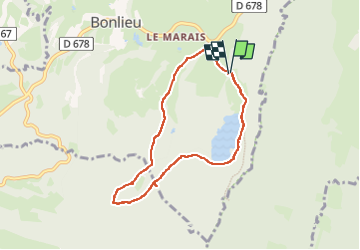

Length
7.1 km

Max alt
862 m

Uphill gradient
110 m
Km-Effort
8.6 km

Min alt
788 m

Downhill gradient
111 m
Boucle
Yes
Creation date :
2023-04-10 08:39:13.494
Updated on :
2023-04-10 12:42:01.475
2h42
Difficulty : Easy

FREE GPS app for hiking
 SityTrail
IGN / Geographical institutes
SityTrail Plus
The world is yours!
About
Trail Walking of 7.1 km to be discovered at Bourgogne-Franche-Comté, Jura, Bonlieu. This trail is proposed by micheldutilleul.
Positioning
Country:
France
Region :
Bourgogne-Franche-Comté
Department/Province :
Jura
Municipality :
Bonlieu
Location:
Unknown
Start:(Dec)
Start:(UTM)
720141 ; 5164087 (31T) N.
Comments
