


LE CANDELON 15KM

jpb83
User
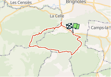

Length
14.9 km

Max alt
769 m

Uphill gradient
664 m
Km-Effort
24 km

Min alt
241 m

Downhill gradient
666 m
Boucle
Yes
Creation date :
2023-04-10 18:36:39.82
Updated on :
2023-04-10 18:36:40.946
2h00
Difficulty : Very easy

FREE GPS app for hiking
 SityTrail
IGN / Geographical institutes
SityTrail Plus
The world is yours!
About
Trail Trail of 14.9 km to be discovered at Provence-Alpes-Côte d'Azur, Var, Brignoles. This trail is proposed by jpb83.
Positioning
Country:
France
Region :
Provence-Alpes-Côte d'Azur
Department/Province :
Var
Municipality :
Brignoles
Location:
Unknown
Start:(Dec)
Start:(UTM)
261624 ; 4807292 (32T) N.
Comments