


SAINT ETIENNE LES ORGUES . LE PONCHON DES CHOUX . 8 JAS O L

RobinMicheline
User GUIDE
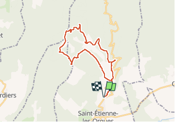

Length
17.2 km

Max alt
1345 m

Uphill gradient
691 m
Km-Effort
26 km

Min alt
801 m

Downhill gradient
690 m
Boucle
Yes
Creation date :
2023-04-11 06:44:28.258
Updated on :
2023-04-11 16:47:37.911
5h14
Difficulty : Medium

FREE GPS app for hiking
 SityTrail
IGN / Geographical institutes
SityTrail Plus
The world is yours!
About
Trail Walking of 17.2 km to be discovered at Provence-Alpes-Côte d'Azur, Alpes-de-Haute-Provence, Saint-Étienne-les-Orgues. This trail is proposed by RobinMicheline.
Description
Belle rando , des petits sentiers , 8 jas beaucoup en ruine helas , montee reguliere et douce
Photos


Positioning
Country:
France
Region :
Provence-Alpes-Côte d'Azur
Department/Province :
Alpes-de-Haute-Provence
Municipality :
Saint-Étienne-les-Orgues
Location:
Unknown
Start:(Dec)
Start:(UTM)
722913 ; 4881806 (31T) N.
Comments