


Cotignac les chapelles

aljac
User
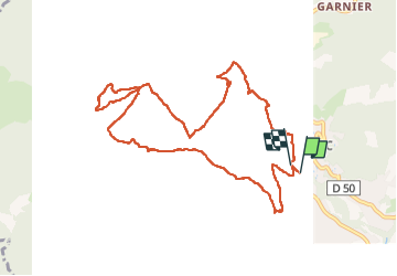

Length
11.2 km

Max alt
458 m

Uphill gradient
283 m
Km-Effort
15 km

Min alt
218 m

Downhill gradient
283 m
Boucle
Yes
Creation date :
2023-04-12 08:09:27.788
Updated on :
2023-04-12 12:59:21.532
3h05
Difficulty : Very easy

FREE GPS app for hiking
 SityTrail
IGN / Geographical institutes
SityTrail Plus
The world is yours!
About
Trail Walking of 11.2 km to be discovered at Provence-Alpes-Côte d'Azur, Var, Cotignac. This trail is proposed by aljac.
Positioning
Country:
France
Region :
Provence-Alpes-Côte d'Azur
Department/Province :
Var
Municipality :
Cotignac
Location:
Unknown
Start:(Dec)
Start:(UTM)
269713 ; 4823040 (32T) N.
Comments