


les clos

ninia
User
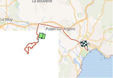

Length
25 km

Max alt
285 m

Uphill gradient
382 m
Km-Effort
30 km

Min alt
2 m

Downhill gradient
467 m
Boucle
No
Creation date :
2023-04-13 06:56:37.371
Updated on :
2023-04-13 10:41:53.65
3h44
Difficulty : Medium

FREE GPS app for hiking
 SityTrail
IGN / Geographical institutes
SityTrail Plus
The world is yours!
About
Trail Walking of 25 km to be discovered at Provence-Alpes-Côte d'Azur, Var, Roquebrune-sur-Argens. This trail is proposed by ninia.
Positioning
Country:
France
Region :
Provence-Alpes-Côte d'Azur
Department/Province :
Var
Municipality :
Roquebrune-sur-Argens
Location:
Unknown
Start:(Dec)
Start:(UTM)
308592 ; 4811699 (32T) N.
Comments