roquebrune /argens Les 25 ponts /lac des clos 2

Michel DUBOIS
User
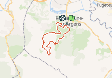

Length
13.2 km

Max alt
286 m

Uphill gradient
409 m
Km-Effort
18.7 km

Min alt
18 m

Downhill gradient
410 m
Boucle
Yes
Creation date :
2023-04-13 13:38:00.104
Updated on :
2023-04-13 13:41:14.812
4h14
Difficulty : Difficult

FREE GPS app for hiking
 SityTrail
IGN / Geographical institutes
SityTrail Plus
The world is yours!
About
Trail Walking of 13.2 km to be discovered at Provence-Alpes-Côte d'Azur, Var, Roquebrune-sur-Argens. This trail is proposed by Michel DUBOIS.
Description
Variante de mon 1er tracé avec moins de grande piste
Positioning
Country:
France
Region :
Provence-Alpes-Côte d'Azur
Department/Province :
Var
Municipality :
Roquebrune-sur-Argens
Location:
Unknown
Start:(Dec)
Start:(UTM)
308508 ; 4812396 (32T) N.
Comments