


Roussillon - Sentier des Ocres

raymondfn
User
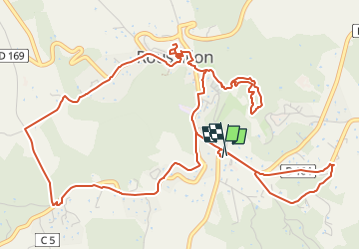

Length
8.5 km

Max alt
336 m

Uphill gradient
194 m
Km-Effort
11.1 km

Min alt
244 m

Downhill gradient
193 m
Boucle
Yes
Creation date :
2023-04-14 15:23:40.867
Updated on :
2023-06-01 17:40:40.809
2h31
Difficulty : Medium

FREE GPS app for hiking
 SityTrail
IGN / Geographical institutes
SityTrail Plus
The world is yours!
About
Trail Walking of 8.5 km to be discovered at Provence-Alpes-Côte d'Azur, Vaucluse, Roussillon. This trail is proposed by raymondfn.
Positioning
Country:
France
Region :
Provence-Alpes-Côte d'Azur
Department/Province :
Vaucluse
Municipality :
Roussillon
Location:
Unknown
Start:(Dec)
Start:(UTM)
684417 ; 4862913 (31T) N.
Comments