


Les Trois Becs

raymondfn
User
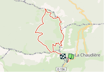

Length
9.4 km

Max alt
1565 m

Uphill gradient
790 m
Km-Effort
20 km

Min alt
1026 m

Downhill gradient
793 m
Boucle
Yes
Creation date :
2023-04-14 16:26:17.825
Updated on :
2023-06-01 17:42:51.675
4h32
Difficulty : Very difficult

FREE GPS app for hiking
 SityTrail
IGN / Geographical institutes
SityTrail Plus
The world is yours!
About
Trail Walking of 9.4 km to be discovered at Auvergne-Rhône-Alpes, Drôme, La Chaudière. This trail is proposed by raymondfn.
Positioning
Country:
France
Region :
Auvergne-Rhône-Alpes
Department/Province :
Drôme
Municipality :
La Chaudière
Location:
Unknown
Start:(Dec)
Start:(UTM)
674800 ; 4944075 (31T) N.
Comments