


2023-04-15_08h54m06_Saint_Rapha_l_Est_rel_Piste_Antibes

gillesdeloddes
User
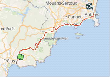

Length
51 km

Max alt
318 m

Uphill gradient
774 m
Km-Effort
62 km

Min alt
-2 m

Downhill gradient
765 m
Boucle
No
Creation date :
2023-04-15 06:54:08.713
Updated on :
2023-04-15 18:44:08.573
0m
Difficulty : Medium

FREE GPS app for hiking
 SityTrail
IGN / Geographical institutes
SityTrail Plus
The world is yours!
About
Trail Cycle of 51 km to be discovered at Provence-Alpes-Côte d'Azur, Var, Saint-Raphaël. This trail is proposed by gillesdeloddes.
Points of interest

Positioning
Country:
France
Region :
Provence-Alpes-Côte d'Azur
Department/Province :
Var
Municipality :
Saint-Raphaël
Location:
Unknown
Start:(Dec)
Start:(UTM)
319424 ; 4810227 (32T) N.
Comments