


AL Saint Leger

phugues
User
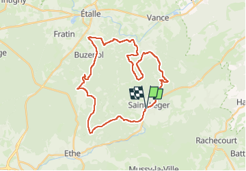

Length
32 km

Max alt
372 m

Uphill gradient
556 m
Km-Effort
40 km

Min alt
229 m

Downhill gradient
557 m
Boucle
Yes
Creation date :
2023-04-16 06:59:31.961
Updated on :
2023-04-16 09:05:34.023
2h05
Difficulty : Difficult

FREE GPS app for hiking
 SityTrail
IGN / Geographical institutes
SityTrail Plus
The world is yours!
About
Trail Mountain bike of 32 km to be discovered at Wallonia, Luxembourg, Saint-Léger. This trail is proposed by phugues.
Positioning
Country:
Belgium
Region :
Wallonia
Department/Province :
Luxembourg
Municipality :
Saint-Léger
Location:
Saint-Léger
Start:(Dec)
Start:(UTM)
691747 ; 5498766 (31U) N.
Comments