


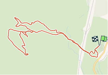
sentier Badaire plateau de l'Arbois

amiral13
User GUIDE

Length
8.2 km

Max alt
230 m

Uphill gradient
164 m
Km-Effort
10.4 km

Min alt
128 m

Downhill gradient
164 m
Boucle
Yes
Creation date :
2023-04-16 09:37:29.159
Updated on :
2023-04-16 11:44:02.268
2h03
Difficulty : Very easy

FREE GPS app for hiking
 SityTrail
IGN / Geographical institutes
SityTrail Plus
The world is yours!
About
Trail Walking of 8.2 km to be discovered at Provence-Alpes-Côte d'Azur, Bouches-du-Rhône, Aix-en-Provence. This trail is proposed by amiral13.
Photos


Positioning
Country:
France
Region :
Provence-Alpes-Côte d'Azur
Department/Province :
Bouches-du-Rhône
Municipality :
Aix-en-Provence
Location:
Unknown
Start:(Dec)
Start:(UTM)
687333 ; 4817698 (31T) N.
Comments