


crêtes d'Aucelon

bymarc26
User
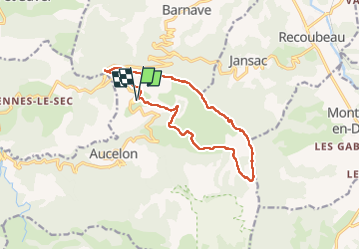

Length
13.8 km

Max alt
1308 m

Uphill gradient
649 m
Km-Effort
22 km

Min alt
859 m

Downhill gradient
649 m
Boucle
Yes
Creation date :
2023-04-16 07:38:24.011
Updated on :
2023-04-16 15:04:43.206
4h40
Difficulty : Difficult

FREE GPS app for hiking
 SityTrail
IGN / Geographical institutes
SityTrail Plus
The world is yours!
About
Trail Walking of 13.8 km to be discovered at Auvergne-Rhône-Alpes, Drôme, Aucelon. This trail is proposed by bymarc26.
Description
Attention qq passages ne sont pas faciles car glissants
Photos


Positioning
Country:
France
Region :
Auvergne-Rhône-Alpes
Department/Province :
Drôme
Municipality :
Aucelon
Location:
Unknown
Start:(Dec)
Start:(UTM)
686655 ; 4945395 (31T) N.
Comments