


Angennes m

Rando MLC
User
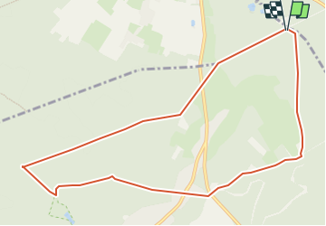

Length
10.5 km

Max alt
191 m

Uphill gradient
112 m
Km-Effort
12 km

Min alt
150 m

Downhill gradient
113 m
Boucle
Yes
Creation date :
2023-04-16 16:19:16.68
Updated on :
2023-04-16 16:20:57.386
2h43
Difficulty : Medium

FREE GPS app for hiking
 SityTrail
IGN / Geographical institutes
SityTrail Plus
The world is yours!
About
Trail Walking of 10.5 km to be discovered at Ile-de-France, Yvelines, Poigny-la-Forêt. This trail is proposed by Rando MLC.
Positioning
Country:
France
Region :
Ile-de-France
Department/Province :
Yvelines
Municipality :
Poigny-la-Forêt
Location:
Unknown
Start:(Dec)
Start:(UTM)
410699 ; 5395712 (31U) N.
Comments