


Sommet de Calern + Bories-17-04-23

Christiancordin
User

Length
14.2 km

Max alt
1452 m

Uphill gradient
449 m
Km-Effort
20 km

Min alt
1100 m

Downhill gradient
448 m
Boucle
Yes
Creation date :
2023-04-17 08:09:50.427
Updated on :
2023-04-22 16:51:35.915
3h42
Difficulty : Medium

FREE GPS app for hiking
 SityTrail
IGN / Geographical institutes
SityTrail Plus
The world is yours!
About
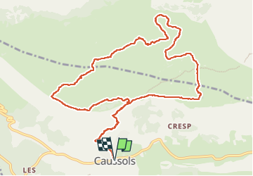
Trail Walking of 14.2 km to be discovered at Provence-Alpes-Côte d'Azur, Maritime Alps, Caussols. This trail is proposed by Christiancordin.
Description
PK mairie de Caussols-ND de Calern-sommet de Calern 1458m-les Baumes-les bories-les dolines-observatoire de la Côte-d'Azur.
Photos


Positioning
Country:
France
Region :
Provence-Alpes-Côte d'Azur
Department/Province :
Maritime Alps
Municipality :
Caussols
Location:
Unknown
Start:(Dec)
Start:(UTM)
330912 ; 4845292 (32T) N.
Comments