


orgeres

Yolande Olivier
User
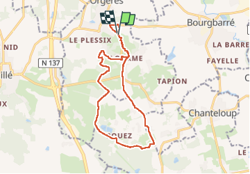

Length
15.1 km

Max alt
107 m

Uphill gradient
169 m
Km-Effort
17.4 km

Min alt
48 m

Downhill gradient
170 m
Boucle
Yes
Creation date :
2023-04-07 11:45:03.983
Updated on :
2023-04-17 13:44:37.429
3h14
Difficulty : Difficult

FREE GPS app for hiking
 SityTrail
IGN / Geographical institutes
SityTrail Plus
The world is yours!
About
Trail Walking of 15.1 km to be discovered at Brittany, Ille-et-Vilaine, Orgères. This trail is proposed by Yolande Olivier.
Description
rando
Positioning
Country:
France
Region :
Brittany
Department/Province :
Ille-et-Vilaine
Municipality :
Orgères
Location:
Unknown
Start:(Dec)
Start:(UTM)
599837 ; 5316236 (30T) N.
Comments