


Gland du 18-04-2023

VANDERPUTTENMi
User GUIDE
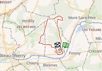

Length
11.2 km

Max alt
226 m

Uphill gradient
232 m
Km-Effort
14.3 km

Min alt
66 m

Downhill gradient
232 m
Boucle
Yes
Creation date :
2023-04-18 06:30:12.173
Updated on :
2023-04-19 09:30:40.848
3h15
Difficulty : Difficult

FREE GPS app for hiking
 SityTrail
IGN / Geographical institutes
SityTrail Plus
The world is yours!
About
Trail Walking of 11.2 km to be discovered at Hauts-de-France, Aisne, Gland. This trail is proposed by VANDERPUTTENMi.
Positioning
Country:
France
Region :
Hauts-de-France
Department/Province :
Aisne
Municipality :
Gland
Location:
Unknown
Start:(Dec)
Start:(UTM)
534019 ; 5433014 (31U) N.
Comments