


Le camps

Orres
User
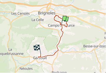

Length
19.8 km

Max alt
344 m

Uphill gradient
292 m
Km-Effort
24 km

Min alt
237 m

Downhill gradient
245 m
Boucle
No
Creation date :
2023-04-18 06:50:07.824
Updated on :
2023-04-18 10:53:11.824
2h09
Difficulty : Medium

FREE GPS app for hiking
 SityTrail
IGN / Geographical institutes
SityTrail Plus
The world is yours!
About
Trail Walking of 19.8 km to be discovered at Provence-Alpes-Côte d'Azur, Var, Camps-la-Source. This trail is proposed by Orres.
Positioning
Country:
France
Region :
Provence-Alpes-Côte d'Azur
Department/Province :
Var
Municipality :
Camps-la-Source
Location:
Unknown
Start:(Dec)
Start:(UTM)
264778 ; 4807671 (32T) N.
Comments