


Étape 3 de la balade du chien en Alsace

Regisconraud
User
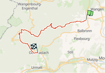

Length
25 km

Max alt
704 m

Uphill gradient
795 m
Km-Effort
35 km

Min alt
197 m

Downhill gradient
720 m
Boucle
No
Creation date :
2023-04-19 05:45:54.795
Updated on :
2023-04-19 14:06:48.988
8h19
Difficulty : Very difficult

FREE GPS app for hiking
 SityTrail
IGN / Geographical institutes
SityTrail Plus
The world is yours!
About
Trail Walking of 25 km to be discovered at Grand Est, Bas-Rhin, Westhoffen. This trail is proposed by Regisconraud.
Positioning
Country:
France
Region :
Grand Est
Department/Province :
Bas-Rhin
Municipality :
Westhoffen
Location:
Unknown
Start:(Dec)
Start:(UTM)
385082 ; 5384370 (32U) N.
Comments